Google Earth Helps and Worries Government
Photos Captured By Government Satellites Now Accessible On Internet
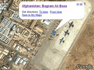
The secretive National Geospatial-Intelligence Agency is rushing to get the latest, high-definition satellite photos of Afghanistan into the hands of U.S. ground troops as they ramp up operations in the country's tangled terrain.
The NGA analysts aren't tapping the government's huge network of highly classified spy satellites; they're getting the pictures from commercial vendors. That's the same stuff pretty much anyone can get, either through free, online programs, such as Google Earth, or by buying it from the same companies supplying Uncle Sam.
It's a remarkable turn, given the warnings that security experts in the USA and worldwide raised a few years ago about giving the entire planet — terrorists and rogue states included — access to high-resolution satellite photos once available only to superpowers.


2 comments:
Wow. You kind of expect not to see your politicians standing beside you in the Wal-Mart toothpaste aisle, and that's exactly what this feels like.
I don't trust the liberal illuminati will manage to make this country more secure, or keep it as safe as it is; but I do have hope that at least it takes highly trained people to know what they're looking at, identify the significance of what they're looking at, and carry out any plans on that information.
HEllo Reagan:
Life and health issues have had me away for a few days...I may be liberal, but it always surprises me what one can find online without much work that our government says is TOP SECRET...then when you find it, they deny it exists. My point being, if I can find it, so can the terrorist...this whole Google Map issue merely confirms what I already knew.
Post a Comment